NJ25_web
25/40
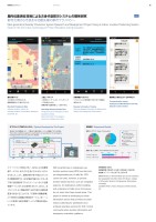
避難に要した時間|Time Needed for Evacuationアプリあり|With app0’000’301’001’302’002’30540000’5454545454アプリなし|Without app2’01アプリなし|Without appアプリあり|With appすぐ行けたEvacuated quickly8.3%45.8%25.0%20.8%16.7%62.5%20.8%ちょっと迷ったが行けたNot sure of way but able to evacuateずいぶん迷ったHad trouble finding way無回答No answer避難のしやすさ|Ease of Evacuation 基本災害マップ火災場所などが表示される。避難誘導員などの場所が分かる。Standard Emergency Map Indicates location of fires, etc.Indicates location of evacuation assistance personnel, etc. 人流ヒートマップ人流測位センサーにより、リアルタイムで人口密度が分かる。避難誘導の基礎情報として活用できる。Heat Map Showing People Flow People flow sensor indicates real time population density. Basic information for emergency personnel in guiding evacuation.災害情報タイムラインリアルタイムの災害情報が市民や地下街職員に通知される。Disaster Information TimelineReal time disaster information is distributed to visitors and underground mall workers.職員同士・防災センターとのやりとりCommunication among Underground Mall Workers and with Disaster Control Center将来的には非常電源により、災害時にも屋内測位システムが駆動することを想定。The indoor positioning system is eventually to be operated by the emergency exit light power source in case of a disaster.IMESBLEビーコンBLE beaconWi-FiビーコンWi-Fi beaconWi-FiアップリンクWi-Fi uplinkWi-Fi人流センサーWi-Fi people flow sensorマイクロコントローラMicrocontroller停電対策バッテリEmergency batteries誘導灯Emergency exit light屋内位置測位技術による次世代型防災システムの開発研究都市災害から市民を守る最先端の都市テクノロジーNext-generation Disaster Prevention System Research and Development Project Using an Indoor Location Positioning SystemState-of-the-Art Urban Technology to Protect Residents during Disasters研究依頼主 総務省共同研究者 西尾信彦(立命館大学情報理工学部教授)所在地 ホワイティうめだ地下街(大阪市)等Client Ministry of Internal Affairs and CommunicationsCo-researcher Nobuhiko Nishio (Professor, College of Information Science & Engineering, Ritsumeikan University)Location Whity Umeda Underground Mall (Osaka), etc.スマートフォンの普及に伴い、GPSによる位置情報サービスは、私たちの生活に欠かせないものとなりました。しかし、建物内部や地下街などのいわゆる閉鎖空間では、GPS電波が届かないため、地下街の目的施設までのナビゲーションなどの位置情報サービスがいまだ実用化されていません。本プロジェクトは、閉鎖空間でも歩行者の位置を精度高く特定することができ、「災害時の避難誘導」と「平常時の店舗案内等商用サービス」をシームレスに実現する都市情報サービスの開発を目指しています。With smartphones in widespread use, location services using GPS have become an indispensable part of daily life. GPS cannot be used, however, to provide location-based services, such as navigation systems, for destinations within buildings and underground malls since microwaves do not reach into these closed areas. This project is aimed at developing an urban information service that provides accurate indoor positioning for pedestrians and achieves seamless services for both normal commercial store-location information and emergency evacuation guidance.NSRI本プロジェクトで制作したシステム|System Developed by This Project実験結果|Experiment Results252015 Winter 25
元のページ