NIKKEN SEKKEI URBANISM
122/136
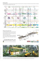
NIKKEN SEKKEI URBANISMLONG VISIONS120 _ 121Rental CycleW.C.SignageDrinkingFountainInterective SignageRental-cycle vending machineStorageBike Repair ShopShower RoomInformation BoothStepsBenchSignageBarLouverRestaurant / KitchenPlatforms serving community needs21 Platforms providing basic functions along the whole stretch are divided into four types of sizes. Each of them is located corresponding to the function of the space and its relationship with the path system.Various sizes of platform are created using a modularized system to allow for exible composition, incorporating the necessary number of units to accommodate the required functions.STORAGEROOMLOST &FOUNDCOINLOCKERRESTAU-RANTFIRSTAIDBIKERENTALSHOWERROOMHANDICAPWCWCINFOR-MATIONDRINKINGWATERRESTAREAXLLMSMAIN PATHNODEPLATFORM(S)PLATFORM(L)PLATFORM(M)PLATFORM(XL)SECONDARY PATHSECONDARY PATHRail Corridor21 Platforms of varied sizes provide locations to stop along the 24KM long space, providing basic functions such as toilets, drinking fountains, shower rooms, etc.Each is located corresponding to the functional characteristics of that space, its relationship with the path system and surrounding community.EASTAT GRADE7.15KM7.65KM10.50KM10.05KM10.25KM11.20KM11.65KM11.70KM16.80KM17.75KM22.25KM0.56KM0.00KM22.50KM12.90KM13.05KM18.50KM19.00KM5.60KM5.85KM0KM123456789101112131415161718192021222324KMMILESTONESTHE LIFEGENERATORTHEPASSAGE OFLIGHTTHECULTURALVALLEYTHE ECO-LOOPTHESTATIONGARDENTHECOMMUNITYCAVETHEGREENCONNECTORTHE AGRI-TERRACETHECANALVILLAGETHENORTHERNNEXUSTOPOGRAPHY &CROSSINGS+103+110+126.1+133+109.6+103.9IMPROVEMENT OF ACCESSIBILITY PEDESTRIANOVER BRIDGEOVER PASSUNDER-PASSNEIGHBORHOODENTRANCEPASTSPEEDFUTURE1.4M/S9M/S14M/S0M/SELEVATIONSECTION OF PATHEast of Rail CorridorWest of Rail CorridorRail CorridorINTERVENTIONArea of InterventionArea without InterventionPLATFORMSOld StationXLLMSPLAYERSGrass-dominated vegetationScrubland vegetationRegenerating forestBack mangrove vegetationBIODIVERSITYAlexander Rd.RAIL CORRIDORKampong Bahru Rd.Ratin Mas FlyoverBukit Merah CentralCommon Wealth Ave.North Buona Vista Rd.Henderson Rd.Hoy Fatt Rd.Alexander Rd.W Coast Hwy.Lower Delta Rd.E Sussex Ln.Holland Rd.Holland Rd.Pan Island Exp.Jin BangketBukit Timah Rd.Jln AsasDiary Farm Rd.Chesnut Dr.Cashew Rd.Hazel Park TerracePetir Rd.Chua Chu Kang Rd.CanalSenjia WayKranji ExpresswayChua cho Kang North 7Mandai RoadRasok Dr.Turf Club Ave.Woodlands Rd.Equestrian WalkBKEWoodlandCrossing Tanjong Pagar Railway StationNorth Buona Vista Rd.Tanglin Halt Rd.Ghim Moh Rd. Bukit Timah Railway StationPan Island Exp.Jin Jurong KechilHindhede DriveTruss Bridge Truss Bridge Truss Bridge Former Bukit Timah Fire StationOld Jurong Rd.HillviewRd.GombakDr.Stagmont RingSungei Kadut Ave.KranjiLoopKranjiRoadWESTResidentialBusiness ParkCivic/CommunityEducationTransportationReserved SIteGreenWaterLAND USEMRTMRTMRTMRTPCNPCNPCNPCNPCNPCNPCNPCNPCNPCNPCNHumeAve.Mandai EstateACTIVITIES8 STRETCHES10 NODESCONCRETEASPHALT2.5m4mHERITAGEAdaptive Reuse of Historic BuildingsTruss Bridges and Historic StructuresOld Stations and Railway MemoryCultural HeritageQVBVHBDBTPIEFSCCKSRKRJOGGINGWEDDINGSFESTIVAL GATHERINGREST & REHABCONTEMPLATINGYOGAWALKINGEAT & DRINKMOVIE FESTIVALNATURE WALKSKATEBBQPLAYINGWALL CLIMBINGBICYCLEFOR RENTEAT & DRINKSPORTSMEDITATIONBIOLOGY SAMPLINGNATURE WALKVIEW POINTYOGABIRD WATCHINGJUNGLE TREKKINGECO EDUCATIONCAMPINGCONTEMPLATINGBATS WATCHINGWALLCLIMBINGURBAN FARMINGRIVERFRONT JOGGINGHAWKERSPLAYINGBIRD WATCHINGBICYCLEFOR RENTFARMERs’ MARKETGARDENINGJOGGINGCYCLINGEAT & DRINKCOOKING PARTYTERRACE GARDENNINGCONTEMPLATINGDRAGON BOAT RACEKAYAKINGBIRD WATCHINGBICYCLEFOR RENTWALKINGTOURIST INFOTOURIST INFOEAT & DRINKMANDAI VIEW DECKLEARNING ABOUT MANGROVECONTEMPLATINGNATURE RELATED ACTIVE & SPORTSEXISTING ACTIVITIESAMENITIESCOMMUNITY GATHERINGSFOOD & RETAILPUBLIC GATHERINGS EXHIBITIONCONCERTBICYCLEFOR RENTMARATHON RUNNERSFASHION SHOWTIME TRAVELLINGLIBRARYCYCLINGWALKINGTOURIST INFOTRANSITOUTDOOR CONCERTBICYCLE FOR RENTParallel PathShared PathSeparated path with pedestrian priorityHHHGoGH1.5mWOOD DECK3.0mCONCRETE2.0mCONCRETE BLOCK4.0mCONCRETESTEPS1.5m2.0mBOARD WALKAlexandra Rd.One North LinkHolland Rd.Pan Island Exp.Mandai Rd.Upper Bkt Timah Rd.SECRET GARDENGATEWAY AVENUEENERGY LINKFOREST WALKGREEN HEARTBOTANIC HILLSCANAL FRONTNORHTERN CREEKChoa Chu Kang Rd.TPRSTanjong PagarAlexandra HaltTanglin HaltBukit TimahBukit PanjangMandaiWoodlandsPlatformPlatformPlatformPlatformPlatformPlatformAlexandraPlatformQueenswayTanglin HaltPlatformHollandPlatformFirst Diversion CanalPlatformBukit MerahPlatformHendersonPlatformJalan Kilang BaratBTRSPlatformPIE ViaductPlatformPlatformFormer BTFSHillviewPlatformCashewPlatformChoa Chu KangPlatformMandaiPlatformWar MemorialPlatformMandai CanalPlatformKranjiStagmont RingWoodlandMethodology MatrixSince the Rail Corridor is a multi-dimensional entity with complex surrounding environments, various aspects of and along the corridor were studied in comparative context by dynamically overlaying them within a matrix.
元のページ