

World's First Standard Specifications for a Digital Twin of a City Covering Both Outdoor and Indoor Areas Established
~Ahead of Society 5.0, the Ministry of Land, Infrastructure, Transport and Tourism (MLIT) is integrating indoor space models into the 3D city models of “Project PLATEAU” to promote the development of use cases that lead to diverse value creation in areas such as disaster prevention, the environment, and urban development~
PRESS RELEASE
2023.03.29
Nikken Sekkei Co., Ltd. (Head Office: Chiyoda-ku, Tokyo; President & CEO: Atsushi Omatsu; hereinafter "Nikken Sekkei") is participating in "Project PLATEAU," led by the Ministry of Land, Infrastructure, Transport and Tourism. We hereby announce the results of the "Research on the Collaboration between 3D City Models and BIM (Building Information Modeling, hereinafter "BIM"*1) for Digital Twin Construction) conducted by the Digital Agency, in collaboration with Nikken Sekkei Research Institute Co., Ltd. (Head Office: Chiyoda-ku, Tokyo; President & CEO: Hiroki Asakura), Asia Aviation Measurement Co., Ltd. (Head Office: Shin President and CEO juku-ku, Tokyo; CEO: Jin Hatakeyama), and buildingSMART Japan (Shibuya-ku, Tokyo; CEO: Junichi Yamashita).
"Project PLATEAU," led by the Ministry of Land, Infrastructure, Transport and Tourism
Project PLATEAU, led by the Ministry of Land, Infrastructure, Transport and Tourism, is a project focused on the development, utilization, and open data sharing of 3D city models.As a foundation for Society 5.0, the project is building and maintaining 3D urban models—which serve as digital twins of cities—so that anyone can freely access urban data. Use case development is underway across various fields—including disaster prevention, the environment, urban planning, regional revitalization, tourism, and mobility—aimed at solving social issues and creating new value.
Background of Development: Achieving the integration of BIM data into 3D urban models, which had previously posed numerous challenges
Conventional 3D city models (LOD 0–3) were constructed by surveying buildings from the outside, resulting in representations that consisted solely of exterior shapes without detailed building information. Consequently, while they were suitable for relatively large-scale analyses, they lacked sufficient information to support continuous planning or services extending from the interior of buildings to the surrounding urban areas.Consequently, efforts have been underway worldwide to integrate BIM—which contains detailed 3D building geometries (walls, doors, stairs, rooms, etc.) and attribute information (floor area, materials, etc.)—into 3D city models that include roads and topography.However, since existing BIM data often lacks location information and technical challenges—such as the loss of attribute data during the conversion process—have existed, its use has been limited until now.
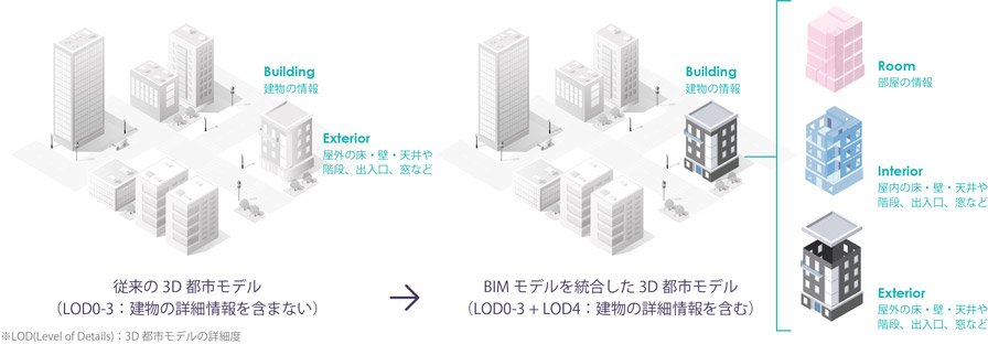 Figure 1: Conceptual Illustration of Integration Between a 3D City Model and BIM
*1 BIM (Building Information Modeling): A building information model that combines primarily 3D geometric data created on a computer with attribute information about the building, such as room names and areas, material and component specifications and performance, and finishes. Throughout the construction process, multiple BIM models are created depending on the purpose and phase.
Key Features of the New Standard Specifications for 3D City Models and Data Conversion Tools
Through this research project, Nikken Sekkei has established the world’s first standard specifications for 3D urban models that include detailed structural information on indoor spaces (CityGML 2.0 Building Model (LOD4) *2) and data interoperability specifications for BIM (IFC *3).This enables the seamless visualization of both outdoor and indoor spaces, facilitating the development of new use cases that span both indoor and outdoor environments—such as planning evacuation routes from rooms to shelters, simulating views while accounting for the impact of surrounding buildings, and providing wayfinding guidance that includes public spaces within a site.We have also developed a tool that converts existing BIM data (IFC 2x3 format) to the Project PLATEAU standard specification. Going forward, if BIM data created during architectural design is prepared in accordance with this specification, it will accelerate the enhancement of 3D city models and contribute to the realization of Society 5.0.
Potential Use Cases
The specifications developed this time are designed for use cases such as indoor mapping, environmental simulation, movement simulation (e.g., evacuation), and line-of-sight analysis.It is capable of handling simulations that take into account the relationships with surrounding buildings, as well as use cases that span both indoor and outdoor environments. For example, as shown in the figure on the right, by simulating movement across multiple buildings rather than a single building, it becomes easier to develop disaster prevention plans on a regional scale.
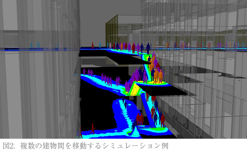 Figure 2. Example of a simulation showing movement between multiple buildings
The specifications developed this time are designed for use cases such as indoor mapping, environmental simulation, movement simulation (e.g., evacuation), and line-of-sight analysis.It is capable of handling simulations that take into account the relationships with surrounding buildings, as well as use cases that span both indoor and outdoor environments. For example, as shown in the figure on the right, by simulating movement across multiple buildings rather than a single building, it becomes easier to develop disaster prevention plans on a regional scale.
Looking Ahead
Nikken Sekkei, which advocates “Social Environmental Design”—an approach that addresses various contemporary social challenges through the creation of outstanding urban and architectural designs and management systems—will continue to support the vision of Project PLATEAU and advance development and collaboration toward the realization of urban digital twins.
For more details on this initiative, please also refer to the official Project PLATEAU website.
For more details on this initiative, please also refer to the official Project PLATEAU website.
About Nikken Sekkei
Nikken Sekkei is a professional services firm specializing in architectural and civil engineering design and supervision, urban design, and related research, planning, and consulting services. For 120 years since its founding in 1900, Nikken Sekkei has been committed to creating value through "social environment design," which aims to solve both explicit and implicit social issues, in order to meet the demands of society and the diverse needs of its clients. To date, it has been involved in various projects in Japan, China, ASEAN, and the Middle East, and in recent years has expanded into India and Europe.
*2 CityGML 2.0 LOD 4 (Buildings): CityGML 2.0 is an international standard data format for handling 3D urban models, as proposed by the OGC (Open Geospatial Consortium).Levels of Detail (LOD) are defined according to the level of detail in 3D urban models. While LOD3 depicted only the building’s exterior shape and openings, the LOD4 (Buildings) standard developed by Nikken Sekkei now enables the depiction of detailed interior structures.
*3 IFC (Industry Foundation Classes): An international standard data format for three-dimensional building information (BIM) models established by buildingSMART International. As part of this initiative, we have developed definitions and a manual for adding location information to architectural design BIM models based on IFC 2x3 Coordination View 2.0.
*3 IFC (Industry Foundation Classes): An international standard data format for three-dimensional building information (BIM) models established by buildingSMART International. As part of this initiative, we have developed definitions and a manual for adding location information to architectural design BIM models based on IFC 2x3 Coordination View 2.0.
About Our Partner Companies
(1) Nikken Sekkei Research Institute, Inc.
・Headquarters Address: 2-18-3 Iidabashi, Chiyoda-ku, Tokyo
・Representative Director and President: Hiroki Asakura
・Date of Establishment: January 1, 2006
・Business Activities: Research and studies on urban management, urban design, and the environment and energy
・Representative Director and President: Hiroki Asakura
・Date of Establishment: January 1, 2006
・Business Activities: Research and studies on urban management, urban design, and the environment and energy
(2) Asia Aerial Surveys Co., Ltd.
・Headquarters Address: 6-14-1 Nishi-Shinjuku, Shinjuku-ku, Tokyo
・Representative Director President and CEO: Hitoshi Hatakeyama
・Date of Incorporation: February 26, 1954
・Business Activities: Geospatial Information Services; Social Infrastructure and National Land Conservation-Related Businesses
・Representative Director President and CEO: Hitoshi Hatakeyama
・Date of Incorporation: February 26, 1954
・Business Activities: Geospatial Information Services; Social Infrastructure and National Land Conservation-Related Businesses
(3) buildingSMART Japan, a General Incorporated Association
・Address: 1-25-5 Yoyogi, Shibuya-ku, Tokyo
・Representative Director: Junichi Yamashita
・Date of Establishment: April 19, 1996
・Purpose of Establishment: Data sharing and interoperability in the construction industry
・Representative Director: Junichi Yamashita
・Date of Establishment: April 19, 1996
・Purpose of Establishment: Data sharing and interoperability in the construction industry
Contact information regarding this matter
株式会社日建設計 広報室 Tel. 03-5226-3030 e-mail:webmaster@nikken.jp
SHARE