

Development of a 3D LiDAR System That Measures Pedestrian Traffic in Real Time and Applies the Data to the Evaluation of Urban and Architectural Spaces
Used for spatial renovations aimed at creating a vibrant atmosphere, energy-efficient control of facilities, and evacuation guidance during disasters
PRESS RELEASE
2023.11.15
Nikken Sekkei Co., Ltd. (Head Office: Chiyoda-ku, Tokyo; President & CEO: Atsushi Omatsu; hereinafter "Nikken Sekkei") has collaborated with Denso Corporation Wave (Head Office: Chita District, Aichi Prefecture; President: President and CEO Takayoshi Sagara, hereinafter "Denso Wave") to develop 3D-LiDAR※1We have developed a prototype system that uses [technology] to measure foot traffic in real time.
Nikken Sekkei has designed numerous urban and architectural spaces as venues for people to interact and engage in activities. As needs regarding these spaces evolve over time, we believe we can further enhance their value by quantitatively evaluating pedestrian movement during operation, identifying spatial challenges, proposing improvements, and applying these insights to facility management.We have begun full-scale operation of this system on a pilot floor at Nikken Sekkei’s Tokyo office.
Nikken Sekkei has designed numerous urban and architectural spaces as venues for people to interact and engage in activities. As needs regarding these spaces evolve over time, we believe we can further enhance their value by quantitatively evaluating pedestrian movement during operation, identifying spatial challenges, proposing improvements, and applying these insights to facility management.We have begun full-scale operation of this system on a pilot floor at Nikken Sekkei’s Tokyo office.
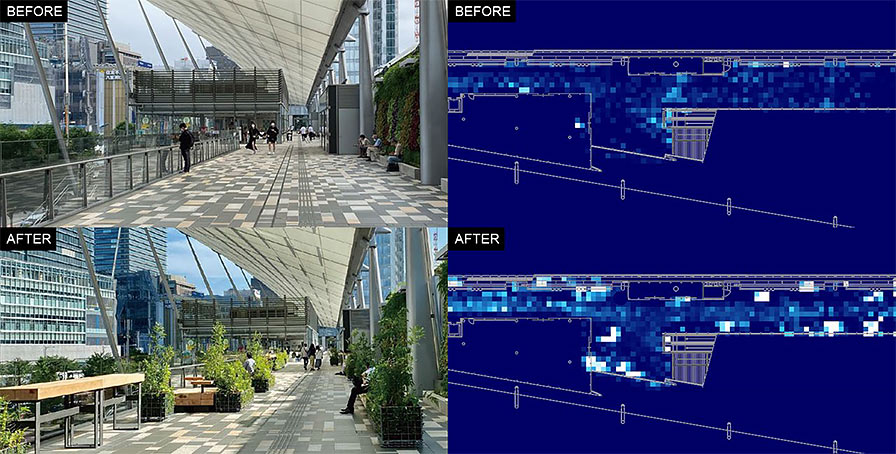 Figure 1. Conceptual illustration of space improvement proposals based on occupancy data
(Verifying the impact of installed furnishings on how people spend time in a space to realize more comfortable spatial proposals)
Track people's movements and stays in real time and apply that data to spatial analysis
In recent years, people flow measurement technology using 3D LiDAR—which has been applied to autonomous driving and traffic volume surveys—offers advantages such as higher positioning accuracy compared to cameras and beacons, as well as the ability to perform real-time measurements without collecting Private information.On the other hand, recognizing human shapes from large volumes of point cloud data requires enormous computational resources, and there has been the challenge that operation and processing are computationally intensive when attempting to track the movements of an unspecified number of people within a large space.
Therefore, Nikken Sekkei and Denso Wave incorporated a post-processing algorithm (patent pending) based on the premise that “people do not suddenly appear or disappear” into an analysis method that extracts moving objects by calculating the difference between point cloud data from the current time and the previous time.This has enabled the realization of a 3D-LiDAR system that does not lose track of moving objects even when they stop, allowing for the tracking of human movement and dwell times with minimal computational resources.By understanding which spaces are being used, when, and by how many people, this system can be utilized for renovation plans based on actual usage patterns; energy-saving control of facilities linked to pedestrian flow and adjustments to robot routes; and, through real-time monitoring of pedestrian flow, evacuation guidance during disasters and crowd detection during events.
Therefore, Nikken Sekkei and Denso Wave incorporated a post-processing algorithm (patent pending) based on the premise that “people do not suddenly appear or disappear” into an analysis method that extracts moving objects by calculating the difference between point cloud data from the current time and the previous time.This has enabled the realization of a 3D-LiDAR system that does not lose track of moving objects even when they stop, allowing for the tracking of human movement and dwell times with minimal computational resources.By understanding which spaces are being used, when, and by how many people, this system can be utilized for renovation plans based on actual usage patterns; energy-saving control of facilities linked to pedestrian flow and adjustments to robot routes; and, through real-time monitoring of pedestrian flow, evacuation guidance during disasters and crowd detection during events.
Case Study: Tokyo Station Yaesu Development “GRANROOF GARDEN”
At the Tokyo Station Yaesu Development and GranRoof, which were completed in 2013, we conducted an effectiveness evaluation using this system in areas where new plantings and street furniture had been installed in advance as part of the renovation of a approximately 234-meter-long pedestrian deck aimed at revitalizing public spaces.According to the analysis of data collected by this system, the number of people lingering in the area increased by approximately 12% on weekdays and approximately 84% on weekends, confirming that the space, which had previously been used primarily for passage, had been transformed into a space for lingering. This evaluation led to the decision to make a significant investment in renovating the entire length of the deck.
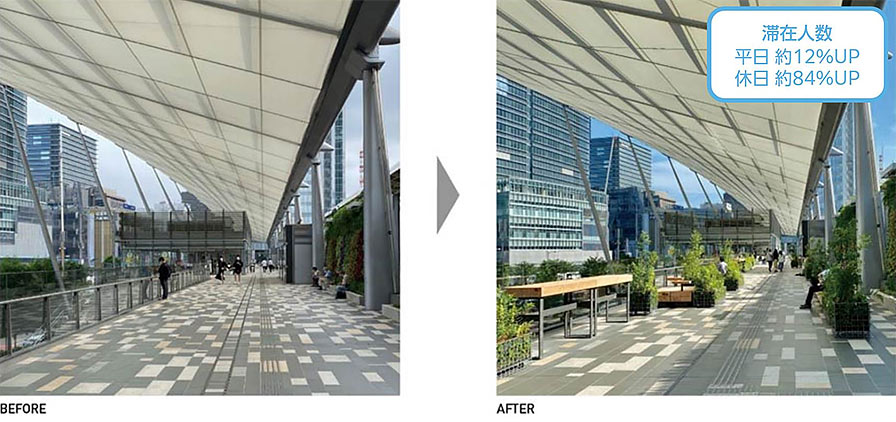 Figure 2. Scene from the effectiveness verification at a previously improved site
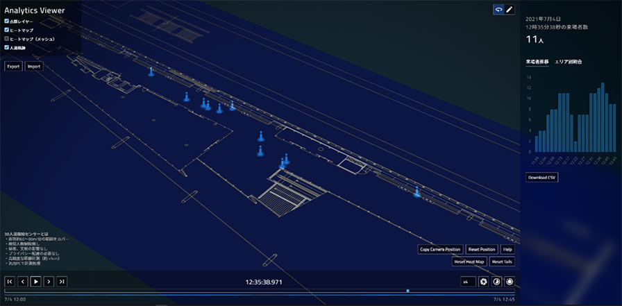 Figure 3. Screenshot of the system interface
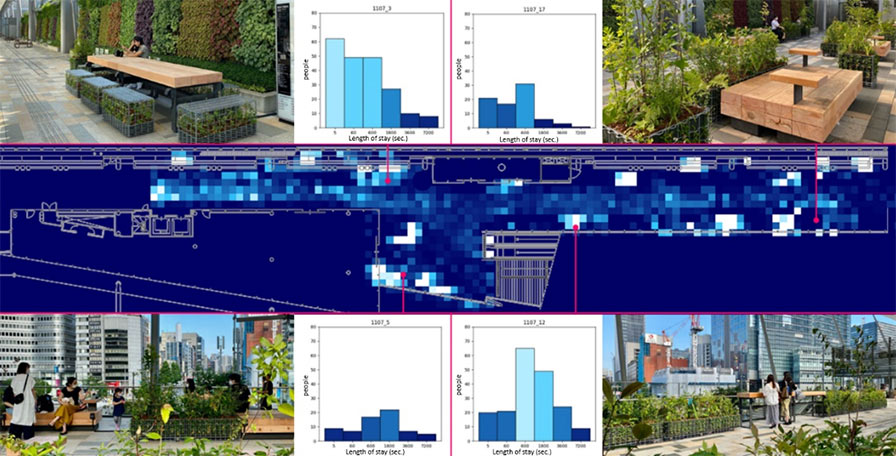 Figure 4. Illustration of the evaluation results obtained using this system
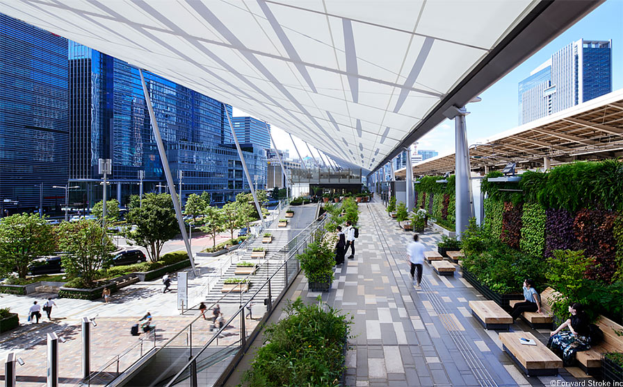 Figure 5. View of the “GRANROOF GARDEN” on the second floor of the renovated GranRoof
Outlook for the Future
Nikken Sekkei plans to utilize this system to identify spatial issues and propose improvements. As part of its effort to develop energy-saving controls for building systems linked to foot traffic, the firm plans to begin testing lighting controls that adjust based on the number of occupants at its Tokyo office in 2024. Additionally, in the future, the company plans to use a 3D urban model (Plateau※2) and building models (BIM※3) It is also anticipated that this system will be integrated with other systems. By combining the static data on cities and buildings with the dynamic time-series data acquired by this system, it will be possible to construct a four-dimensional digital twin.
About Nikken Sekkei
Nikken Sekkei is a professional services firm specializing in architectural and civil engineering design and supervision, urban design, and related research, planning, and consulting services. For 120 years since its founding in 1900, Nikken Sekkei has been committed to creating value through "social environment design," which aims to solve both explicit and implicit social issues, in order to meet the demands of society and the diverse needs of its clients. To date, it has been involved in various projects in Japan, China, ASEAN, and the Middle East, and in recent years has expanded into India and Europe.
About Denso Wave
Denso Wave contributes to the creation of a safer and more environmentally friendly society by providing solutions and products that enhance social and industrial productivity.Its business areas are diverse and include the Solutions Business, which provides various systems such as security and cashless payment systems; the Automatic Identification Business, which handles barcode and QR code readers; the Robotics Business, which develops small industrial robots; the Control Equipment Business, which develops security controllers and programmable controllers; and the IoT Business, which develops IoT products to enable digital transformation (DX).
inquiry
株式会社日建設計 広報室 Tel. 03-5226-3030 e-mail:webmaster@nikken.jp
| ※1 | An abbreviation for Light Detection and Ranging. This technology measures the distance to a target by emitting a laser beam and measuring the time it takes for the beam to hit the object and bounce back. With 3D LiDAR, 3D point cloud data is obtained through three-dimensional distance measurement. |
| ※2 | A project led by the Ministry of Land, Infrastructure, Transport and Tourism to create 3D city models of cities across Japan and make them available as open data. |
| ※3 | Abbreviation for Building Information Model. A database created by adding attribute data—such as costs, finishes, and management information—to a three-dimensional digital model of a building created on a computer, in order to utilize building information throughout all phases of a project, from design and construction to maintenance and management. |
SHARE